")
The Africa Groundwater Atlas launches digital hydrogeology maps for 38 countries in Africa at the 46th IAH Congress in Malaga, Spain
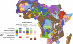
The online, open access Africa Groundwater Atlas was launched in 2016. Bringing together information from multiple sources, it provides an overview of hydrogeology, groundwater resources, and its management for each country in Africa. Furthermore, it includes supporting general information relevant to the African context, for example, on climate, groundwater quality,…


, Civil and Environmental Engineering")